
Before going fishing, it is very important to check the weather. This helps boaters and fishermen know the type of precipitation, wind, and temperatures to expect. When going fishing offshore the wind is the most important thing to inspect as this will determine the wave height. In the marine forecast, the wave height should be listed for specific areas with expected wave heights for that day and several days in the future.
Source: weather.gov
When I am deciding where to fish the wind direction and tides both play a role in that decision. The average person just looks at the temperature and precipitation to determine if it is going to be a nice day. However, when fishing the wind is what actually determines if it is going to be a calm day or a rough day on the water.
Planning your fishing trip or vacation around the weather is actually a good idea. If you are going to be snorkeling, scuba diving, or going offshore make sure that it is done on the days with the lowest wind speeds. Before deciding if I can go fishing offshore during the week or weekend I consistently check the weather to see if it is a good idea to go on the trip.
Here Are the Best Marine Weather Apps
1. NOAA National Weather Service
The best way to check marine or fishing weather is at weather.gov. This is the site for the National Oceanic and Atmospheric Administration, NOAA. It is also referred to as the National Weather Service. When you hear the weather reports over marine radios this is the forecast that is provided. However, on the radio, it can be difficult to understand exactly which area is being described with the predicted wave heights.
Source: weather.gov/key/marine
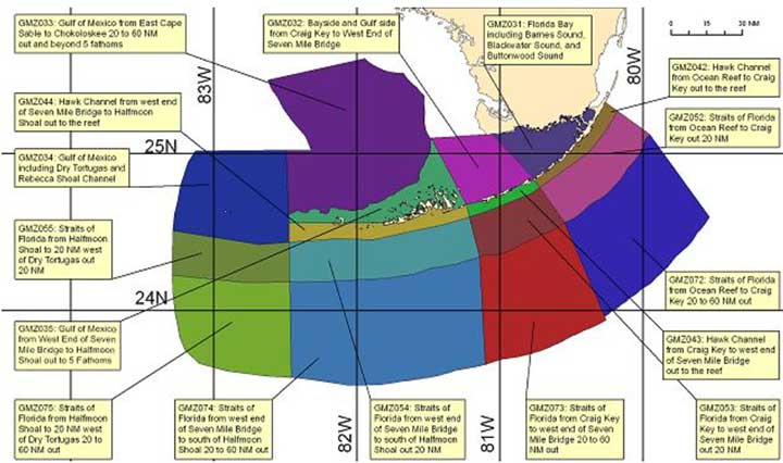
The map above shows the different regions that the weather can be selected in the Florida Keys, for example. This is found on weather.gov. I find this website by typing in marine weather Florida Keys into google. This can also be done for other locations around the United States. Having the regions shown in different colors helps ensure you are getting the weather from the location where you will be boating or fishing. You can also click the regions from the large map of the United States at weather.gov. Personally, I try and find a more local map for the region being fished.
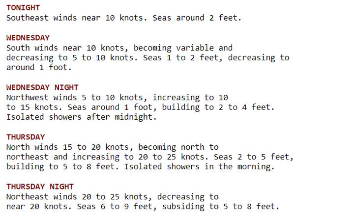
Once you click on the colored area a synopsis of the weather and a description of the area will be provided. Below the synopsis a list of weather conditions for the area. It will detail the estimated wind speed, wind direction, and wave heights. It will also generalize the precipitation forecast. This is a marine forecast and does not provide the expected temperatures.
When checking the marine weather the furthest area offshore you will be going should be checked. It is common for coastal and nearshore waters to have significantly less wave height than further offshore. Also, be mindful of the weather expected later during the day or tomorrow. This will help determine if conditions are expected to get better or worse. Also, realize that unexpected storms can still happen, and boaters should pay attention to nearby weather and check boat radar or ground radar for real-time reports when needed.
2. Windfinder
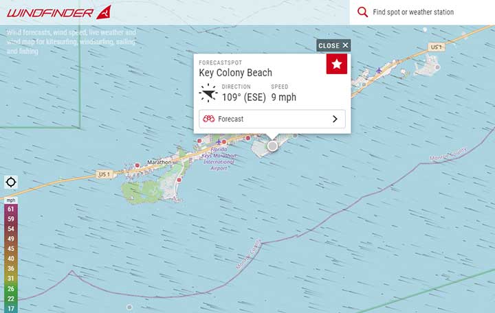
Windfinder is another popular website used to check marine weather. The best way to find a specific location is to start in map view. Most of the locations that can be selected are along the coast. However, there are buoys and lighthouses offshore that can be selected. Some of these areas are actual weather stations where the historical and real-time wind measurements and temperatures can be viewed.
Source: windfinder.com
In the map view, the red or gray dots can be selected to see a forecast at that location. By selecting “Forecast” a detailed forecast will be provided. The map itself has small dots moving across the screen representing the wind direction and speed. Windfinder is a great option to use to see a detailed weather forecast along the coast.
Source: windfinder.com
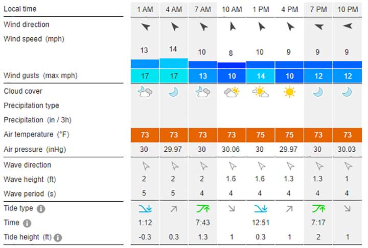
The forecast above can be seen at any of the source locations on Windfinder. This is for one day but a full 10-day forecast is typically provided. This wind speed and direction are the first items shown. The average wind speed and wind gust speeds are provided. Often times this information is provided at airports and is also helpful to pilots. Unlike weather.gov the temperature and cloud cover is also provided. The precipitation is estimated in inches per 3 hours. This will also show raindrops to signify that rain is expected. Next, the most important item for boating and fishing is the wave direction and wave height. In addition, the period between waves is given in seconds. This allows mariners to know if the waves are spread out or are going to be short choppy waves.
Finally, the tidal information is provided. A diagram is used to show if the tide is a high tide or low tide. It also shows the tide height in feet. All of the details provided by this website is very informative. Checking the weather gives you a good picture of what to expect on the water. The only downside to this site is the forecast are marked at limited locations offshore. If you fish, boat, or going to be on the shore, Windfinder is a great way to get the marine weather forecast. When going offshore it is still important to check weather.gov. Windy.com is a similar wind website but does not have detailed weather reports in specific areas.
3. The Weather Channel
The Weather Channel is the most popular way to check the weather. The forecast can be checked for the day, hourly, 10 day, weekend, or even monthly. Toward the bottom of each of these forecasts is an option to see the radar map. Click see radar and a full view of the radar will be provided.
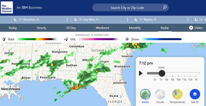
Source: weather.com
When viewing the radar there is a play button to watch the radar. When it plays it will show the weather of the past hour leading up to the current moment. There is also an option to see the future radar play up to 6 hours into the future.
Looking at the past radar gives great insight into the expected precipitation in the next few hours. It is not a good long-term predictor of weather. However, it lets you see if there are any major storms in the area that could be of concern. It is common for storms to grow out of no visible system so it is still good to check the forecast and watch the weather in the area at all times.
In my experience, the predicted weather is not that accurate. However, the past weather is actual data and you can predict yourself where the weather is going to be in the next few hours pretty accurately. This is important to do just before you leave so there are not any unexpected storms that should have been expected.
Source: weather.com
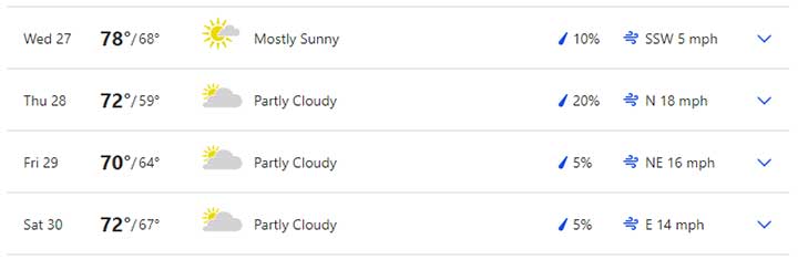
The ten-day forecast provides the high and low temperatures, cloud cover, the percent chance of precipitation, wind speed, and wind direction. What is missing is the expected wave heights. These can typically be estimated based on the direction and speed by an experienced boat captain. What is also missing though is the wind speeds and expected weather conditions offshore. These weather forecasts are usually on land.
4. Buoyweather
Source: buoyweather.com
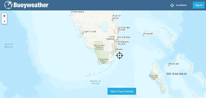
Bouyweather is both a website and an app. It allows for free two-day weather and marine forecasts. For extended forecasts, a fee of around $15 per month is required. The two-day forecast does work pretty nicely though.
To use the map, simply place the cursor on the desired area and click the “View 2-Day Forcast” button. From there a report with the wind speed, wave height, weather forecast, and tides will be provided. It is very nice that any area can be easily selected. I have not used this site much thought to know if the forecasts are accurate. The site is easy to use but I am not sure it is worth the premium cost considering this information can be found elsewhere for free. Actually, most other sites do not provide a 15-day forecast so this is a possible reason to get the subscription. I would not count on the forecast being very accurate though more than 10 days out.
5. Rutgers Sea Surface Temperature SST
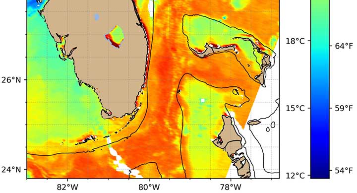
Source: marine.rutgers.edu
Rutgers University has a website that shows updated Sea Surface Temperature plots that are available online for free. These plots are not real-time but are updated several times per day. Often overlooked by fishermen but the temperature of the water is an important factor when considering fishing conditions. Along the temperature breaks, there can be rip lines that trap nutrients resulting in a higher concentration of bait and game fish. Also, this data can show the distance the Gulf Stream is from the shore.
These plots are shown for large regions but do have enough detail to provide useful information. When using the site just click the are of interest. The time shown on the plots is GMT with is 7 hours ahead of the eastern standard time. For this reason, sometimes the plots appear to be in the future but that is just because of the time zone used.
6. Navionics
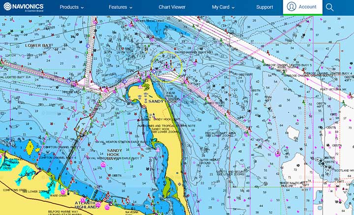
Source: webapp.navionics.com/
Navionics is not actually a weather app but it is important to have a good navigational display when in adverse weather on a boat. There is a website that shows all the land, water depths, and channel locations. When the app is used the vessel location is shown within the map. In poor visibility conditions, it is important to be able to navigate. Also depending on the wind direction having a map showing the land features allows you to find locations the will be protected from the wind and waves.
7. Tides4Fishing
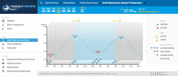
Source: tides4fishing.com
Tides4Fishing is a site with lots of information. It has detailed weather forecasts including temperature, wind direction, wind speed, the chance of precipitation, and the UV index. There is a lunar calendar available that provides the moon phase forecast. It also provides the water temperature which unique to most weather websites. The app for this company is called Nautide and it is available on both the google play store for android and the App Store for the iPhone and Apple products.
At the bottom of the tide chart, it also shows fish icons representing times where there might be higher fish activity. I do not always agree with these values as the best tides to fish does depend on the location. In general, fishing a changing tide is best. There are times where the solar and lunar activity does make for much more actively feeding fish. In saltwater what the tides are doing is a major factor in whether fish are going to bite.
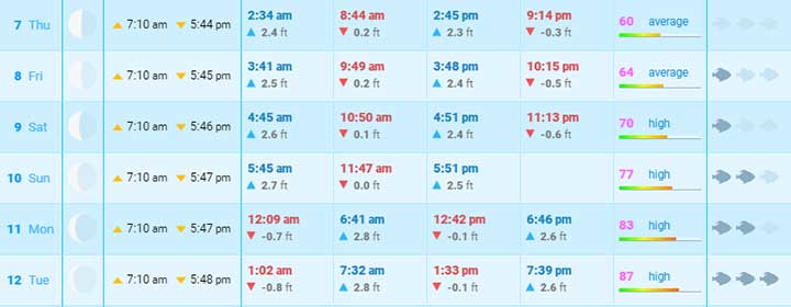
Source: tides4fishing.com
Toward the bottom of the report, there is an extended tide forecast for the month. What is interesting about this is the far right column shows the Solunar activity which is an estimate of how active the fish bite will be based on the solar and lunar activity.
Maine Weather Questions
What is the best weather app for fishing?
The best way to check the weather before going fishing is to use the NOAA website at weather.gov. There is also a NOAA marine weather app for smartphones. The NOAA website is a widely used resource for boaters and fishermen. It provides an estimate of wind speed, wind direction, and wave height. The weather is forecast based on grids that can be located nearshore or offshore. This provides people that are going boating a good idea if the waves will be small enough to go fishing. Often times the wave heights are two large and angles need to change their plans to fish closer to shore in protected water.
What weather app do fishermen use?
Fishermen use several weather apps including, NOAA, Windfinder, The Weather Channel, Bouyweather, and Tides4Fishing. There are also apps and websites that show the Sea Surface Temperature which can help in selecting a fishing spot. Some apps will also show an estimate of Chlorophyll in the water which is highly correlated to the amount of plankton. This is another tool some fishermen use to decide a good location to fish. Most fishermen pay close attention to the wave heights and tides before going on a fishing trip.
What weather is best for fishing?
The best weather for fishing depends on the type of fish being targeted. In freshwater fish tend to bite the best early in the morning and around sunset. During sunny afternoons it can be difficult to get fish to bite. During these times baits need to be presented naturally and in close proximity to fish. Rainy overcast days can be a great time to catch freshwater fish. During the spring and early summer, bass are commonly found in the warmer shallower water along the banks of lakes and ponds.
In saltwater, the weather is not super important and fish activity is much more correlated to the tides. However, if it is too calm or too wavy it can make it less likely for fish to bite. The water visibility also plays into getting fish to bite baits and lures. In general, though there is a strategy that will work for most weather conditions in the ocean.
How are sea conditions predicted?
Sea conditions are largely base on waves. What is considered important is the wave heights and wave periods. The driving factor for wave height is wind speed and the length of time that the wind has to act on the wave. This means that if the wind is coming from the direction behind land the nearshore waves will be small. If the wind is coming at the shore the waves are going to be much bigger. Also in large shallow water areas, waves will not build at tall as in deep waters. This makes predicted waves heights somewhat difficult but also important. A person with lots of experience on the water will know for a given wind speed and direction about how big the waves are going to be. If you are not experienced then you should read into all the details of the weather forecast before going offshore.
How should you check the marine weather before going boating or fishing?
The most important thing which checking marine weather is how big the waves are going to be. If you have a 20-foot boat going out in waves larger than 3 feet with short wave intervals is going to make for an uncomfortable day on the water. Depending on the size of the boat, hull design, distance going offshore, and experience on the water all play into what type of weather anglers are comfortable fishing in safely. How the conditions are expected to change should also be looked at. If there is a small craft advisory all recreational anglers should think twice before going offshore.
Outside of wave height, the chance of storms and precipitation should be looked at. If it is going to rain but not storm then bringing proper rain gear might be all that is needed. Looking at the UV index, temperature, and cloud cover will determine if sunscreen and UV clothing is needed. It is always a good idea to bring a hat and polarized sunglasses when going on a fishing trip. If it is going to be rough people tend to get seasick. Leaving people that get motion sick behind on rough days is a good idea. Also having some type of ginger ale helps some but there is not a major way to fix seasickness on the water.
Captain Cody has worked on charter fishing boats in the Florida Keys, Virgin Islands, and Alaska. Growing up in Pennsylvania Cody has also done extensive freshwater fishing including bass fishing tournaments. Cody strives to provide detailed information about the best fishing gear and tactics to help both novice and experienced anglers have a more productive and enjoyable time on the water. Cody also has a background in aerospace engineering and neuroscience but really only takes pride in being good at one thing and that is fishing!